HomeTopicsThe AmazonTapajos under attack 8: The rush to turn the Amazon into a...
Tapajos under attack 8: The rush to turn the Amazon into a soy transport corridor
The Amazon’s rivers once were sufficient for commerce; now international commodities traders want to build roads, railways and industrial waterways thru the Amazon’s heart.
The development over the last 40 years of Mato Grosso state in Brazil’s interior as an industrial agribusiness powerhouse has, from the beginning, been hindered by a major economic problem: how to get the commodities to the coast for profitable export.
The first route of export from Mato Grosso was a costly and time-consuming southern one, with commodities trucked on a circuitous route to Santos in São Paulo state and Paranaguá in Paraná state on the Atlantic coast.
The paving of the northern section of BR-163, running south to north through Pará state, opened a much less expensive, faster route, with commodities now moved to Miritituba on the Tapajós River, then downstream to the Amazon, and on to Europe and China.
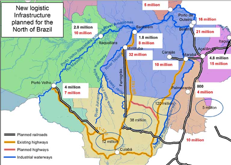
New infrastructure plans call for the channelization of the Juruena, Teles Pires and Tapajós rivers, creating a 1,000-mile industrial waterway. Two railways, one over the Andes, are also proposed. These schemes pose grave threats to the Amazon rainforest, biodiversity, indigenous and traditional communities, and even the global climate.
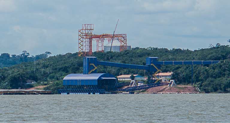
Symbols of today’s Amazon: a grain terminal and a riverboat. Brazil’s government and the ruralista industrial agriculture lobby insist that major transportation infrastructure is needed to meet future soy export demands — including two new railways and a 1,000-mile-long industrial waterway to move soy commodities to both South American coasts. This development could do considerable harm to Amazon forests and biodiversity. Photo: Walter Guimarães
(Leia essa matéria em português no The Intercept Brasil. You can also read Mongabay’s series on the Tapajós Basin in Portuguese at The Intercept Brasil)
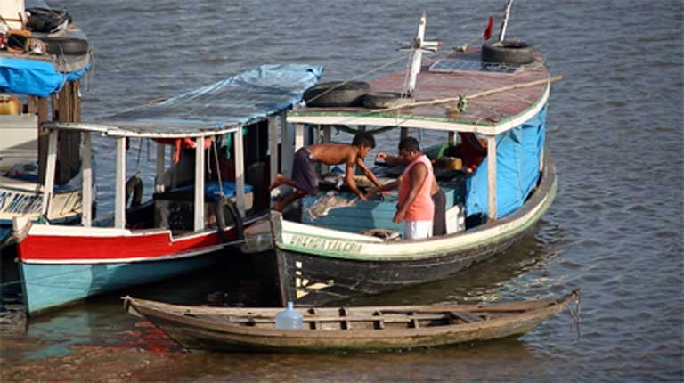
The Tapajós River Basin lies at the heart of the Amazon, and at the heart of an exploding controversy: whether to build 40+ large dams, a railway, and highways, turning the Basin into a vast industrialized commodities export corridor; or to curb this development impulse and conserve one of the most biologically and culturally rich regions on the planet.Those struggling to shape the Basin’s fate hold conflicting opinions, but because the Tapajós is an isolated region, few of these views get aired in the media. Journalist Sue Branford and social scientist Mauricio Torres travelled there recently for Mongabay, and over coming weeks hope to shed some light on the heated debate that will shape the future of the Amazon. This is the seventh of their reports.Santarém is one of the Amazon’s oldest towns, site of a thriving and populous AmerIndian community for centuries, but officially founded in 1661 by the Jesuits. It arose close to the famous “meeting of the waters,” where the greenish flow of the Tapajós River floods into, then parallels for several miles, the coffee brown waters of the Amazon.
The community long served as a departure point for adventurers and traders headed to the Amazonian wild. Until recently, it exuded an attractive, old-fashioned beauty with its dilapidated colonial buildings; a riverside market where locals hawked freshly caught fish, herbal remedies and indigenous handicrafts; and a bustling river port where small fishing boats and canoes mixed with elegant three-story riverboats — packed with passengers lounging in hammocks, ready for the voyage ahead.
The river beckoned then. After all, it was the main way to easily get anywhere.
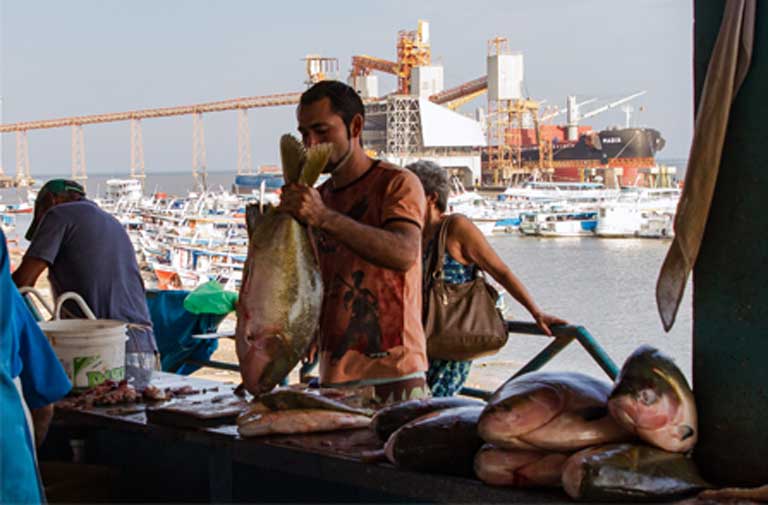
The Santarém fish market. The Cargill commodities terminal looms in the background. Photo: Thais Borges
But in 2003, that all began to change with the construction of a large grain terminal built by Cargill, America’s largest commodities company. Though it stayed unused for many years, gradually trucks coming from Mato Grosso state, laden with soybeans and corn, began to struggle their way along the rugged and rutted BR-163 highway, bringing noise and congestion as they cut through the town to reach the terminal.
Although Santarém itself was later to be somewhat marginalized as an Amazon transportation hub, these events heralded a new future for the Tapajós basin.
Agribusiness in Brazil’s interior had at last found a cheaper way to move farm commodities north by road to the Tapajós and Amazon rivers, then on to the Atlantic coast and to lucrative commodity markets abroad — sparking growth in Pará state that has been gaining force ever since.
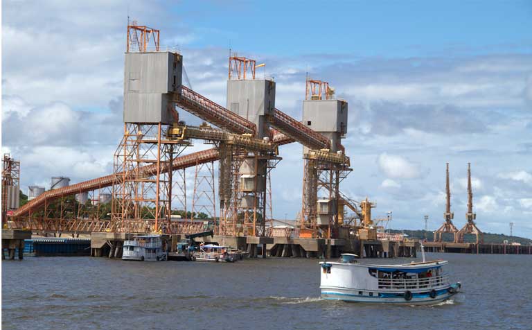
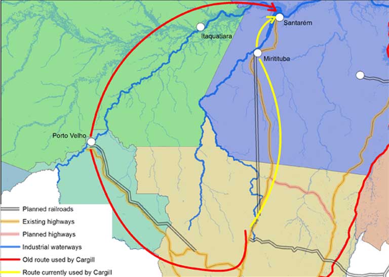
The Bunge commodities terminal in Miritituba on the Tapajós River. Tapajós basin fishermen have complained that the Miritituba port has polluted the river with soy, which has negatively impacted the fishery. Photo: Mauricio TorresExisting and planned agricultural commodities transportation export routes in the Amazon’s interior. This infrastructure includes highways, railways and industrial waterways running from soy-producing Mato Grosso state toward both South American coasts. Map: Mauricio Torres
The road south
It wasn’t Cargill but the state-owned agricultural research company, Embrapa, that first brought agribusiness to Brazil’s interior — first to the state of Mato Grosso and then farther north to the state of Pará. Next came Monsanto, and then other biotechnology companies, providing large-scale farmers (who could afford it) with ”technological packages,” all-in-one setups including GM seed, fertilizer and pesticide, along with a guaranteed purchase of the crop.
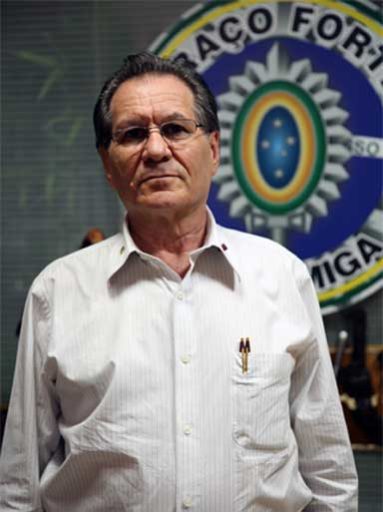
Jorge Baldo lobbied for heavy investments early on, to make the southern part of the BR-163 highway passable year round — a project regarded as “a total utopia” as the road was little more than a set of mud ruts through the rainforest at the time. “Little by little, we won over one person and then another, created the pro-BR-163 Committee, and we started to make demands,” remembered Baldo. Photo: Thais BorgesWith the expansion of agribusiness in Brazil’s interior, and its increasing dominance in the Brazilian economy, it became clear that Mato Grosso and Pará needed much better transportation infrastructure to deliver the goods, something seen as obvious as early as 1994 by commodities analyst Jorge Baldo.
During our November 2016 Tapajós visit, we met him, a self-taught man and a passionate nationalist, in the town of Sorriso in Mato Grosso. Sitting at his desk, a military coat of arms on the wall behind, he told us that the farming sector in Sorriso, very small in the early 90s, went through a serious crisis in 1994, just like agriculture all over Brazil. The Bank of Brazil was prepared to roll over the farmers’ debts to help them, recalled Baldo, but he realized that this aid by itself would not be enough: “The producers needed inputs. And we didn’t have a road! It took a week for anything to come from Cuiabá!”
Baldo began calling for heavy investments to make the southern portion of the BR-163 highway passable at all times of the year — a project regarded as “a total utopia” as the road, though technically asphalted, was little more than a set of mud ruts through the rainforest at the time.
“Little by little, we won over one person and then another, created the pro-BR-163 Committee, and we started to make demands,” he remembered. Slowly the BR-163 was properly asphalted, with the pavement moving north from Cuiabá, but it took until 2007 before Sorriso had a reliable transport link to the south. Finally the town had the conditions it needed to become Brazil’s “agribusiness capital.”
The BR-163 highway, as it was before paving, showing clearly why Mato Grosso agribusiness wanted it asphalted and improved. Photo courtesy of TV Taquari
BR-163’s asphalt allowed Mato Grosso’s crops to be exported south along pot-holed roads to Santos in São Paulo and Paranaguá in Paraná state on the Atlantic coast. There commodities were transferred to Transatlantic vessels in which they travelled back north for another 1,400 miles before going east to Europe or going west through the Panama Canal to China. This lengthy trip was expensive and unreliable: docks in the southern ports were often so crowded that the trucks could wait up to 60 days to be unloaded.
The way north
Agribusiness became increasingly frustrated by the cost and delays of the southern route, realizing that, if the commodity-laden trucks could just roll north along the then unpaved northern section of BR-163, they could cut the trucking distance in half by unloading their cargo into ships at Santarém on the Amazon River.
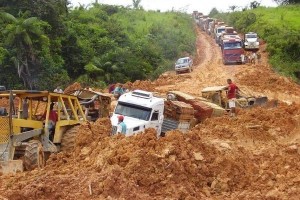
But at the time, the highway north to Santarém was very precarious in the summer, and with winter rains, it became utterly impassable. Travelling along the BR-163 in 2004, it took us almost three days to cover a mere 140 kilometers (85 miles). Stuck in the road’s ruts, with hundreds of other trucks and cars, we had to choose between sweltering inside our vehicle, or being devoured by mosquitoes outside. Two in our group got malaria. It became clear to us that as an export route, the unpaved northern part of BR-163 was unviable.
That’s when Blairo Maggi came up with an interim solution. Maggi, who was a Mato Grosso political force to be reckoned with then, and who now serves as Brazil’s Agriculture Minister, got the highly controversial MT-235 built through the Utiariti indigenous reserve, achieving a new road link, whereby soy could travel northwest by truck to the Madeira River and then northeast by barge to Santarém.
This served the Maggi family (which was, and is, very invested in the soy business) and some other farmers in the region too. But it was logistical nonsense for the farmers in the northern part of the state, whose beans were now driven along two sides of a triangle to get to market. Even so, the farmers said, it was better than taking the soy south.
Gaming the commodities transport system
Cargill was the first grain trader to bet on the “exit to the north,” building its terminal in 2003 on an archaeological site within Santarém. But, in the early days, according to Cargill’s Clythio Buggenhout, because the BR-163 was unusable, it too was forced to use the indirect MT-235/Madeira River transport link opened up by Maggi.
The MT-235 was not the only road Maggi built. Throughout our November 2016 journey, farmers spoke of the logistic help the politician offered, particularly when Mato Grosso state governor from 2003-2010. Dal’Mazo, former mayor of the town of Sinop, told us: “Blairo Maggi is a very intelligent person. He always helped the region.… He opened roads for his own products, but then he let everyone use them. So why would anyone complain?”
In 2003, President Lula’s Workers’ Party finally announced plans to pave the northern section of BR-163. In response, the multinational grain companies rushed to open terminals on the Tapajós River. Bunge was there first, constructing a transhipment terminal in the new port of Miritituba, opposite the town of Itaituba on the Tapajós.
Commodities on the move on the much-improved BR-163 highway. Photo: Roosevelt Pinheiro, courtesy of Agência Brasil
At last, commodities transport logistics were making sense: the road journey north was now 650 miles shorter than the route south, and the trucks could unload their cargo onto barges, which travelled down the lower Tapajós to the Amazon River, and then east to the ports of Bacarena near Belém, and Santana near Macapá, the capital of Amapá state.
Bunge then carried out a master stroke against competitor Cargill. Bunge sold half the assets in its Miritituba-Barcarena complex to Amaggi, the Brazilian company belonging to Blairo Maggi’s family, dramatically increased Amaggi’s stake in the export business — which is where the greatest profits are to be made. “This new step strengthens our presence in the region and also contributes to the growth of a key logistics route,” declared Amaggi CEO Waldemir Loto at the time.
But in truth, while the deal benefited Amaggi, it was even better for Bunge, because Blairo Maggi immediately put his political muscle, along with large sums of public money, behind the Miritituba-Barcarena river port complex. In 2004, the government apparently pressured by Maggi), announced that the last 172 kilometers (107 miles) of the BR-163, taking it to Santarém, would not be paved.
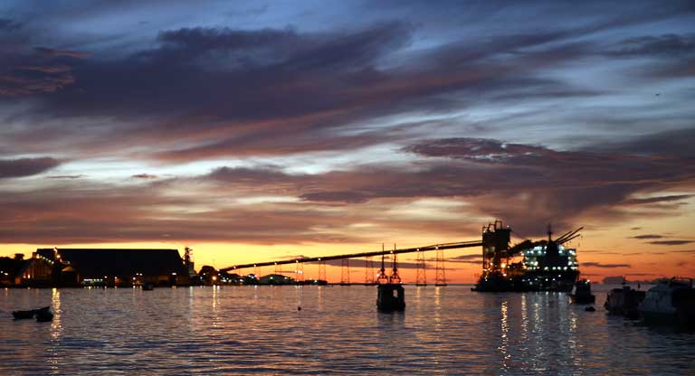
An Amazon grain terminal at night. International and Brazilian agribusiness interests are pushing hard to turn the Tapajós basin into an industrialized commodities corridor so it can handle future soy production coming out of Brazil’s interior. “It will be easy to increase [the state’s] soy production to 68 million tons by 2022, provided we are given [global] conditions in which we can compete,” Carlos Henrique Fávaro, vice-governor of Mato Grosso and a soy farmer, told Dinheiro Rural. Photo courtesy of Mayangdi InzaulgaratCargill’s Santarém terminal was now stranded at the end of a muddy road, and commodities traffic started flowing instead to Miritituba, where the asphalt ended. The governor of Pará, Simāo Jatene, protested: “The largest city in the lower Amazon cannot be excluded from the paving of the Br-163!” But excluded Santarém was, and Cargill was eventually forced to build its own terminal in Miritituba.
“Miritituba is an obvious road-and-river entrepôt, it’s a meeting point,” declared Cargill director Clythio Buggenhout in 2013. “It opens a range of logistic alternatives.”
The rainforest and people that get in the way
The ramping up for all this transportation infrastructure has come with a price. The first victim was the rainforest. In the year following Lula’s announcement of the paving of the northern part of BR-163, forest clearing exploded, particularly on either side of the road.
“Ten years later, the levels of deforestation were as bad as in our worst projections,” reported Juan Doblas, who monitors regional deforestation for the NGO Instituto Socioambiental (ISA). “The loss of forest in the region was so out of control that for every year between 2004 and 2013 — except 2005 — while deforestation in Amazonia as a whole fell, it increased in the region around the BR-163.” Márcio Santilli, who helped found ISA, has worked out that 80% of deforestation in the Amazon occurs within 30 kilometers (18 miles) of a paved road. What is happening around the BR-163 shows just how true this observation is.
Fishermen arrive at the Santarém fish market. The Tapajós River commercial fishery is economically vital to the region, and feeds river communities. Plans to tame the Tapajós and turn it into an industrial waterway include dams and reservoirs to make way for soy barges. Experience elsewhere in the Amazon, with the Belo Monte dam on the Xingu River, for example, has shown that dams and reservoirs can cause large fish kills and endanger commercial fisheries. Photo courtesy of Mayangdi Inzaulgarat
Local people, too, have suffered. Pará state environmental secretary José Alberto Colares, warned in 2012 that the go-ahead was being given to construct ports and terminals in Miritituba before the necessary preparatory work had been undertaken.
“The area doesn’t have any of the infrastructure it needs to deal with the social, economic and environmental impact,” he said. “It needs: traffic controls on the roads and the river, energy transmission, public safety, sanitation, health, education, risk assessment, training courses to stop people leaving [the region], rubbish collection, water supply”. This requires significant investment, he said, and the companies shouldn’t expect all the work to be done by the state.
Little attention seems to have been paid to the environmental secretary’s plea. Twenty-six transhipment terminals are now planned for Miritituba, with few of the necessary ancillary support services being included in the investment plans.
In February, 2016 the Federal and State Public Ministries, independent branches of the Brazilian government, went to court to demand that three of the functioning terminals in Miritituba stop operation, partly based on the inadequacy of social and environmental impact studies. The case has not yet been judged.
Some local people have stood up for their rights and won, at least for now. A big port at Santarém might still be under construction today if not for the opposition of quilombola families (descendants of runaway slaves) living there. The National Agency of Water-Road Transport (ANTAQ) was planning to build a big grain terminal beside the lake of Maicá, on the Amazon River, quite close to Santarém.
Remarkably, even though there are seven quilombola communities less than three miles away from the planned complex, environmental impact studies ignored the settlements, stating that ““no quilombola territory exists in the area directly affected by the project”.
The communities mobilized, and turned to the Public Ministries, demanding their right to be consulted. The Federal and State Ministries went to court, asking that the port licence be suspended. In April 2016, a federal judge ruled in favor of the quilombola, and work on the project stopped.
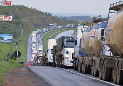
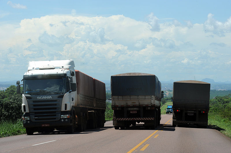
Traffic on BR-163 clearly demonstrates the need for expanded infrastructure. Photo courtesy of Agência BrasilNew Amazon transportation routes and their agribusiness capacities. The numbers in black are each river port’s existing annual handling capacity of grain in tons. The numbers in red are the port’s predicted annual handling capacity in 2026 after planned infrastructure investments and expansions have been made. Source: Presentation by Cargill and SETRAN-PA 26 February 2016
The roads, railways and waterways ahead
As extensive as the transportation infrastructure has become in the heart of the Amazon, the multinational commodity companies and the Pará state government have hugely ambitious plans for it to be expanded even further. According to recent projections by Setran, the Pará Transport Secretariat, by 2026, Miritituba will be able to handle 32 million tons of grain per year, which is more than current soybean production of the whole of the state of Mato Grosso.
But by then Mato Grosso will be producing much more: “It will be easy to increase [the state’s] soy production to 68 million tons by 2022, provided we are given [global] conditions in which we can compete,” a confident Carlos Henrique Fávaro, vice-governor of Mato Grosso and soy farmer in Lucas do Rio Verde, told Dinheiro Rural.
To carry all these commodities, a new railway, called Ferrogrão — running from Sinop in Mato Grosso to Miritituba — has been announced. Costing R $12.9 billion (US $4.1 billion), it will be 933 kilometers (580 miles) long and have an annual handling capacity of 36 million tons of grain. If completed in 2024, as intended, Ferrogrão will provide cheaper freight transport and will remove significant truck traffic from the BR-163, which will soon be clogged at peak times of year.
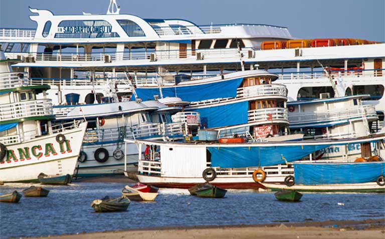
Riverboats continue to be a good way of traveling across the Amazon. If the dozens of dams planned for Amazon tributaries are built, canals with locks will be needed so that shipping, including soy barges, can get around the dams. Photo: Walter Guimarães
There’s more: to ease the pressure on the roads yet further, the agribusiness lobby wants to transform the Juruena, Teles Pires and Tapajós rivers into a 1,000-mile-long industrial waterway, allowing Mato Grosso soybeans and other crops to be containerized and transported by barge downstream all the way to the Atlantic.
Key to the viability of the industrialized waterway is the building of dams and the deepening of the rivers — dynamiting waterfalls and rapids and carrying out other high-impact construction — to create a long series of navigable reservoirs.
In the more distant future, an ambitious 3,300-mile-long railway, built over the Andes to the Peruvian port of Ilo, has been proposed. Although the final route has not been decided, this railway, funded by the Chinese, is likely to run from the newly constructed port of Açu in Maranhão, through Mato Grosso, Rondonia and Acre to the Peruvian border.
Of course, as transportation options multiply, so will the demand for more cropland to grow even more soy and corn, placing even more pressure on the environment and habitat.
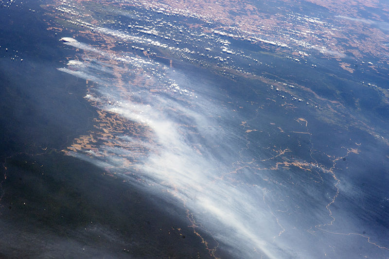
Against the backdrop of Amazonia’s dark green rainforest, fires lit intentionally to clear the land for agriculture follow along the BR-163 highway in 2014, a process that reveals red-brown soils. A long line of newly cleared agricultural patches snakes east from BR-163 toward the remote Rio Crepori Valley. Extensive deforested areas in Brazil’s Mato Grosso state appear in tan at the top of the image. The fires show the advance of deforestation into Pará state, now second after Mato Grosso in terms of deforestation acreage. Photo and analysis courtesy of NASA
Great doubts
Can the Amazon rainforest, and the world, survive this massive Amazon agribusiness onslaught? Perhaps the most ominous warning of dangerous unforeseen consequences comes from renowned Amazon scientist Tom Lovejoy, interviewed in August 2016 by Science, the journal of the American Association for the Advancement of Science. When asked what he considered the greatest threat to the Amazon, Lovejoy responded:
The intersection between uncoordinated infrastructure and the hydrological cycle. The Amazon makes half of its own rainfall [through evapotranspiration], and the water recycles five or six times as it crosses the basin. [Deforestation disrupts] the hydrological cycle [and] is going to have effects on the weather system. With the droughts of 2005, 2010, and the current one [in 2016] — I think we’re seeing flickers of the potential tipping point.
Once the Amazon passes this climate change tipping point, the much-celebrated “lungs of the world” no longer work as a carbon sink — storing large amounts of greenhouse gases — and the region will instead become a carbon source, as the dying rainforest exhales its carbon in torrents into the atmosphere with potentially disastrous results for the planet.
While no one knows with certainty where this deforestation tipping point lies in the Amazon — somewhere between 20 and 40 percent, scientists like Lovejoy guess — the building of dozens of roads, dams and ports in the Tapajós, along with the resultant forest loss, pushes the world toward that invisible point of no return.
With such a potentiality looming just ahead, critics question the rush to develop the Tapajós basin as a commodities transportation corridor at the expense of the Amazon’s environment, its irreplaceable biodiversity, and its indigenous and traditional inhabitants.
Santarém grain port at night. The rush to turn the Tapajós basin into an industrialized commodities transportation corridor could do extensive damage to rainforest, aquatic and terrestrial biodiversity, indigenous and traditional river cultures, and even the global climate. Photo courtesy of Mayangdi Inzaulgarat
This article is funded by readers like you
Only with regular support can we maintain our website, publish LAB books and support campaigns for social justice across Latin America. You can help by becoming a LAB Subscriber or a Friend of LAB. Or you can make a one-off donation. Click the link below to learn about the details.

![An Amazon grain terminal at night. International and Brazilian agribusiness interests are pushing hard to turn the Tapajós basin into an industrialized commodities corridor so it can handle future soy production coming out of Brazil’s interior. “It will be easy to increase [the state’s] soy production to 68 million tons by 2022, provided we are given [global] conditions in which we can compete,” Carlos Henrique Fávaro, vice-governor of Mato Grosso and a soy farmer, told Dinheiro Rural. Photo courtesy of Mayangdi Inzaulgarat](https://lab.org.uk/wp-content/uploads/2017/04/brazil_TP08-09-grain-terminal.jpg)