Subsolo journalist Ruan Martins spent six months tracking online adverts offering millions of hectares of forest in Brazil’s Amazon. He spoke to more than 100 brokers and checked property maps, identifying listings that overlapped Indigenous territories and protected areas, including Tenharim land. At the time of publication, Facebook was still hosting the kind of advert it had promised to block in 2021.
This investigation was originally published in Portuguese as Chapter 1 of Subsolo’s series. Translated for LAB by Stanton Geyer.
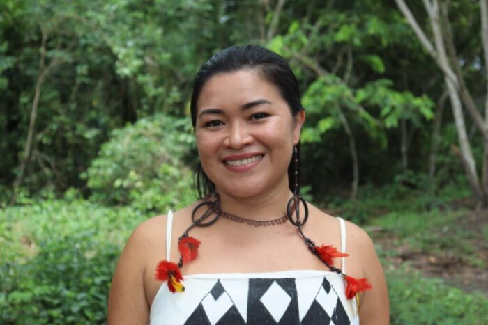
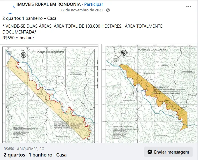
Although Daiane Tenharim knew well the dangers threatening her people’s territory, she felt as if her home were being violated when she saw that part of the Tenharim Marmelos Indigenous Territory in Amazonas was for sale online. A post published in November 2023 in Facebook groups dedicated to Brazil’s land trade advertised 183,000 hectares for R$118 million, a little over 17,000 hectares of which overlapped the Tenharim Marmelos Indigenous Territory. ‘It is a sacred territory, where our ancestors lived. We have old villages, cemeteries, and many Brazil nut trees there that feed our people,’ says Daiane, 34, as she looks at the map of the property.
The daughter of elders from Marmelos village, she is the first woman to coordinate the Associação do Povo Indígena Tenharim Morõgwitá (Apitem – Association of the Tenharim Morõgwitá Indigenous People), founded in 1996. Through the organization, she leads efforts to monitor the territory, using drones and geographic information systems to identify threats. ‘We are seeing more and more non-Indigenous people inside our territory,’ she says.
What is happening on Tenharim land is not an isolated case. An investigation by Subsolo found that numerous properties in the Amazon are being sold illegally through social-media platforms such as Facebook, YouTube, and TikTok, as well as marketplaces such as OLX and MFRural. Set the location on these platforms to an Amazonian town and search for terms such as ‘farm’, ‘forest’, or ‘native forest’, and a long list of adverts appears on screen. Some feature legitimate, properly documented properties. Others, however, show strong signs of land grabbing (grilagem): very large areas, very low prices, and, above all, false or insufficient documentation to prove ownership of the land.
José Heder Benatti, a former president of the Instituto de Terras do Pará (Iterpa – Pará Land Institute) and a professor of agrarian law at the Federal University of Pará, has researched land grabbing for around three decades. He encountered the fraud firsthand while looking online for a smallholding where he could relax after retiring from academic life. ‘There were many options, but almost all were plots of land without enough documentation to prove that the people trying to sell them did, in fact, have the right to own them,’ he says. ‘The problem is that our land market includes both legal and illegal properties,’ he adds.
From advert to map
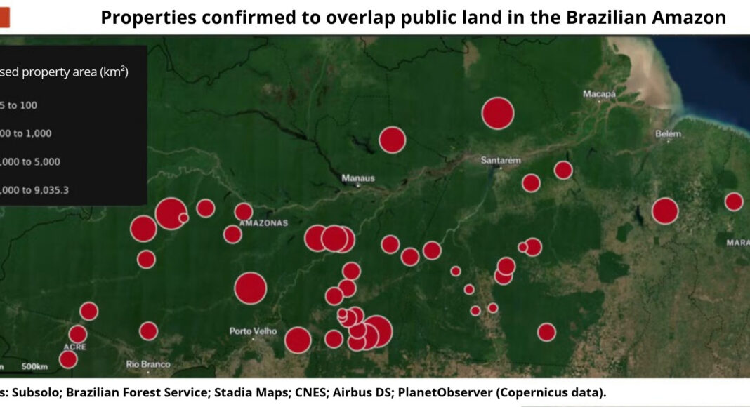
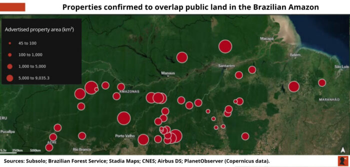
To gauge the scale of the phenomenon, a Subsolo reporter spent six months collecting suspicious online adverts. The investigation identified five million hectares of Amazon forest advertised for sale online, an area larger than either Denmark or the Dominican Republic and larger than the Brazilian state of Rio de Janeiro. Most of the adverts are for land covered by native forest, which helps explain why these properties are offered at such low prices, between R$300 and R$800 per hectare. In the Amazon, cleared land can sell for up to 20 times the price of a forested area.
In all, Subsolo found 112 adverts for rural properties, published between June 2021 and October 2025, covering areas above the constitutional threshold of 2,500 hectares, beyond which land cannot be titled without authorization from Congress. Within this sample, Subsolo confirmed that 39 adverts offered 46 areas overlapping public land, in whole or in part. Most overlap protected areas (unidades de conservação) and Indigenous territories. A single advert may offer more than one property: either the purported owner has more than one area for sale, or the broker has included more than one offer in the same listing. According to information provided by brokers and, in some cases, adverts marked as sold, at least 10 properties in the sample had been sold.
For the remaining 73 adverts in the sample, Subsolo found signs of land grabbing and possible overlaps with public land, but could not confirm the validity of the offers or the properties’ exact locations. These suspected cases covered 4.6 million hectares. Together with the five million hectares confirmed to overlap public land, the investigated adverts covered 9.6 million hectares; of that total, only five million hectares were confirmed as public land. During the investigation, hundreds of adverts were also found showing signs of land grabbing in areas smaller than 2,500 hectares.
Although the adverts can easily be found online, fuller information – such as a property’s documentation, environmental status, and exact location – can only be obtained from the brokers handling the sale. Posing as the assistant to a foreign investor interested in buying a farm in the Amazon, a Subsolo reporter spoke with more than 100 brokers handling the online listings. Their names have been withheld because the land records they shared could expose them to retaliation from the people behind the suspected land grabs.
When land documents were unavailable, the reporter asked for the properties’ KMZ files: compressed geographic data files containing mapping information such as points, polygons, and routes. Brokers usually shared these files without much resistance. These documents and maps made it possible to determine the exact location of the land and, in many cases, identify the people behind the suspected land grabs. To check whether the boundaries of the properties advertised online did indeed overlap public land in the Amazon, Subsolo worked with the Center for Climate Crime Analysis (CCCA), an international organization specializing in environmental crime investigations using geospatial analysis.
On YouTube, an advert offered 14,000 hectares partly overlapping the Caru Indigenous Territory in Maranhão.
On WhatsApp, a broker offered an area of 87,000 hectares entirely overlapping land claimed by the Amanayé people in the municipality of Goianésia do Pará, in south-eastern Pará.
On the Brazilian marketplace MFRural, an advert offered a property of 135,000 hectares partly overlapping the Ararà Indigenous Territory in Amazonas.
On OLX, a Dutch marketplace, a broker advertised a 517,000-hectare property entirely within the Balata-Tufari National Forest, a federal sustainable-use conservation unit in Amazonas.
On Facebook, a broker put 522,000 hectares of land up for sale. Following a parliamentary inquiry in 2001, INCRA asked the Amazonas state judiciary to review the suspect land registrations. Administrative measures subsequently cancelled registrations in the area’s chain of title, returning the land to the public domain.
Facebook Marketplace
Of the adverts collected, including both suspected and confirmed cases, 74 were published on Facebook, which appears to have become the preferred place to do business for land grabbers operating in the Amazon. In general, adverts are first published on Facebook Marketplace and then shared in groups for buying and selling rural properties to extend their reach. By October 2025, Subsolo had found at least 13 large Facebook groups trading rural properties. Together, the groups had more than 800,000 members. The largest was Fazendas à venda no Brasil (‘Farms for sale in Brazil’), with 128,000 members, who posted an average of 150 offers a month, many involving rural properties in the Amazon.
In one curious case, a man wrote in a Facebook group that he was looking for one million hectares of land. ‘Preferably an area of native forest,’ he added. His request drew several comments, almost all from property brokers offering land in Amazonas, the state with the greatest concentration of intact Amazon forest. Subsolo contacted each of the 10 property brokers who replied to the post. None, in fact, had land of that size available for sale, whether in the Amazon or anywhere else in Brazil. Many of them, however, said they had smaller tracts in northern Brazil, ranging from 80,000 to 800,000 hectares.
In 2021, after the BBC revealed dozens of areas of public land for sale on Facebook Marketplace, Meta promised to block this kind of advert. Subsolo’s investigation, however, shows that the promise was not kept.
In a statement sent to Subsolo, Meta said it had not been given access to the links for the adverts collected and that its ‘commerce policies are constantly updated and explicitly prohibit the promotion of the purchase, sale, or exchange of land in ecologically protected areas’. The company added that ‘failure to comply with our policies or the law may result in various consequences, including, among others, the rejection or removal of listings and other content’. Finally, Meta said it works ‘in compliance with regulatory requirements, providing reporting channels, and in partnership with local authorities to address this issue in our apps as effectively as possible over the long term’.
YouTube told Subsolo that it ‘acts promptly when notified of violations of local law’ and ‘assesses and processes notices of unlawful content; such requests must clearly and specifically identify the material (with the exact URLs) and set out the basis for the request’. The platform also said that its official channel for submitting these notices is available through this form.
OLX and MFRural did not respond to Subsolo’s requests for comment.
This approach, previously based on voluntary self-regulation, became subject to legal requirements. In June 2025, Brazil’s Federal Supreme Court ruled that technology companies must be held civilly liable for unlawful content posted by users on their platforms and must create specific channels for requests to remove criminal content.
Land without title
For Ane Alencar, science director at the NGO Instituto de Pesquisa Ambiental da Amazônia (Ipam – Amazon Environmental Research Institute), the vast area of public land that the investigation found for sale online ‘is a symptom of the Brazilian state’s difficulty in governing areas as remote as the Amazon’.
Nowhere illustrates this difficulty better than Novo Progresso, a municipality in western Pará with the largest number of adverts for properties overlapping public land found by the investigation. In total, there were four adverts with confirmed overlaps and another 17 with strong signs of land grabbing. The properties confirmed to overlap public land totalled 45,000 hectares, while those showing signs of land grabbing covered 121,000 hectares.
A property broker contacted by Subsolo gave three reasons why properties in the region lack titles. First, ‘people here want to clear the forest. If the area has title, the fine for deforestation will fall on the owner,’ he explained. ‘Another reason is that obtaining a title can be expensive, and people in Novo Progresso do not want to spend money on the land; what they want is to make money from the land,’ he continued. ‘And there is also a cultural question: as nobody here has ever had a title, they are not going to get one now,’ he concluded.
This ‘culture’, however, runs counter to the law. A 1966 federal law prohibits invading land belonging to the federal government, states, or municipalities with the intention of occupying it. Another federal law, amended in 2006, makes it a crime to ‘clear, economically exploit, or degrade planted or native forest’ on public land without authorization from the competent authorities. Despite these legal restrictions, adverts for illegally appropriated public land are pervasive.
To understand the roots of the problem, Subsolo spoke with geographer Ariovaldo Umbelino, then a professor at the University of São Paulo (USP), a few months before his death in August 2025. Ariovaldo said the adverts found by the investigation presented a ‘bleak picture of land tenure chaos in the Amazon’, the result of five centuries of disorder in the countryside. The 1850 Land Law contributed to this chaos by pardoning invasions of public land that had occurred before it came into force. The law set a dangerous precedent: invasions continued, fuelled by the expectation that future legislation would legalize them. History shows that this expectation was borne out. In 1931, 2008, and 2017, the government established new cut-off dates that, in practice, pardoned earlier occupations and prohibited future ones.
For land to cease to be public, the government must issue a document granting ownership rights over the area. If someone claims to own land but has no document proving ownership rights over it, the land remains public and therefore should not be available for sale.
Prof. Ariovaldo Umbelino, USP
Our people
Located between the municipalities of Humaitá and Manicoré, in southern Amazonas, the Tenharim Marmelos Indigenous Territory covers 473,000 hectares and is home to 741 Indigenous people in 11 villages. The Tenharim refer to themselves as Kagwahiva, a word in their Tupi language meaning ‘our people’. Related peoples from the same linguistic branch, including the Juma, Jiahui, and Parintintin, use the same self-designation.
Most of the Tenharim are evangelical Christians, with six churches in the territory and two more under construction. Ricardo Tavares Albuquerque, a lawyer representing the Tenharim, told Amazônia Real that the community had lost its pajés through years of Catholic and evangelical influence. A pajé is a spiritual authority responsible for invoking and controlling spirits, curing illnesses, foretelling the future, and improving harvests.
Despite their conversion to Christianity, the Tenharim maintain ancestral traditions such as the annual Mbotawa festival, during which they celebrate marriages, honour the achievements of the dead, and mark girls’ passage into adulthood. The celebration begins with an expedition to the southern part of the territory, where their ancestors’ graves and the source of the River Marmelos lie. It is there, in the preserved forest, that the Tenharim hunt, fish, and gather fruit. The aim is to ensure that they, their relatives, and their guests have enough food for the four days of festivities.
On the 2024 expedition, the Tenharim found signs that someone had invaded their territory. ‘We identified some stakes marking out plots driven into the ground in precisely the area you are showing me,’ Daiane told the Subsolo reporter who showed her the map of the property advertised on Facebook, partly overlapping Tenharim territory.

The man claiming ownership of the roughly 17,000 hectares overlapping Tenharim territory is the trader Sebastião Aquiles Monteiro de Souza, great-great-grandson of José Francisco Monteiro, the Portuguese man who began the colonization of southern Amazonas in the second half of the 19th century.
One of the files shared by the broker responsible for selling the property is a Certidão de Inteiro Teor, or full registry certificate. This document reproduces in detail the information contained in the property’s matrícula, or register entry.¹ It includes any debts or court restrictions associated with the property, as well as its ownership history.
The document shared by the broker states that in 1921 Banco do Brasil bought the land at auction to settle the debts of Antônio Francisco Monteiro, the eldest son of the colonizer José Francisco Monteiro. However, it does not make clear how the area returned to the Monteiro de Souza family after being auctioned a century earlier.
The certificate also states that the property’s register entry was blocked by the Amazonas Court of Justice in 2016 because people outside the land’s chain of title were registering the area without authorization. The block was lifted in 2017, but the dispute was never resolved because the court considered that the applicant had abandoned the proceedings. As a result, title to the part of the property outside the Indigenous Territory’s boundaries remains unresolved.
In response to an information request filed by Subsolo, Banco do Brasil said it was not the property’s current owner and that the area had been expropriated by the Instituto Nacional de Colonização e Reforma Agrária (INCRA – National Institute for Colonization and Agrarian Reform) and later transferred to third parties. The bank did not say whether the Monteiro de Souza family was among them.
According to the bank, the records from 1921 are no longer available because it had no automated system at the time and the legal 10-year retention period for such documents has expired. INCRA, for its part, said it had searched its databases, internal systems, and physical and digital archives but found no records, documents, or information that could establish the property’s existence. The agency noted, however, that the search relied on the names of the property’s three parcels, which limited the chances of locating it.
In addition to the dispute involving Banco do Brasil, Monteiro de Souza is involved in at least one other land dispute in Amazonas. In a case reported by the local newspaper A Crítica, he came into conflict with Eletroferro Construções over ownership of the 16,000-square-metre site of the Parque Amazonense Stadium. He also filed a police report accusing the company’s owner of invading his property.
Speaking to the newspaper, Eletroferro’s director and owner accused Sebastião of presenting documents that ‘say nothing’ and serve only ‘to deceive people acting in good faith’. In his defence, Sebastião said that he and his mother were heirs to the land. ‘The area has been part of my great-grandfather Antônio Francisco Monteiro’s estate since 1898. I have all the documents: an alvará, property registration, registration with the municipal authorities. Everything. A piece of land can’t have two sets of possession documents,’ he said.
When approached by Subsolo, Sebastião’s legal representatives set out several requirements before responding to the request for comment, including proof of the reporter’s identity, proof that he was a journalist, and identification of ‘your company’. In his first email, the reporter leading the investigation had properly identified himself, giving his full name, profession, the name of the project, the platform on which the investigation would be published, and the name of an international partner that would republish the work.
After the lawyer replied, links to previous work were shared, along with a link to Subsolo’s webpage, which contains information about the project, including its editorial focus and funders. Despite this, the requests for comment had gone unanswered by the time the article was completed. The opportunity for the defence to respond remains open.
Christian catechization or extermination
The threats against the Tenharim go back a long way, and the history of Sebastião Aquiles’s family is at their centre. After making money as a trader in Maranhão, the Portuguese investor José Francisco Monteiro decided to enter the latex trade, the raw material for rubber. In 1860, he established rubber-tapping stations along the banks of the River Madeira, one of the Amazon River’s main tributaries. Before long, his operation had become the most important in the region, with an estimated 250 to 300 employees.
When Francisco Monteiro arrived in this part of the Amazon, however, an Indigenous group known locally as the Parintintin had already inhabited it for at least 100 years. They farmed, fished, and hunted, moving freely through the region. The arrival of the Portuguese, however, sparked a war between white settlers and Indigenous people. The houses and sheds where Francisco Monteiro’s workers gathered were attacked and looted. In retaliation, the colonizer sent his men against the Parintintin.
As Indigenous resistance showed no sign of ending any time soon, O Humaythaense, a newspaper founded by Francisco Monteiro’s eldest son, declared that there were only two solutions to the conflict: ‘catechization or extermination’ of the Indigenous people.² According to the historian Vitor Hugo, the war between the Portuguese and Indigenous people resulted in the near extinction of the Indigenous population. As the conflict continued, some of the Parintintin separated from the rest of their people and migrated towards the headwaters of the Marmelos, Preto, and Branco rivers in southern Amazonas. The group that broke away is known today as the Tenharim.
Even after the official ‘pacification’ of relations between Indigenous people and white settlers in 1920, the threats against the Tenharim did not end. During construction of the Trans-Amazonian Highway, which cuts through the territory from east to west, disease outbreaks killed many Tenharim. Testimonies from community members also describe Tenharim adults and children being compelled to work without pay on the road project, in conditions they compared to slavery. Against this backdrop, Porantim, a newspaper covering Indigenous issues, published a 1979 article quoting Father José Antônio Sagües, who worked with Indigenous people in the region: ‘Land grabbing is the new epidemic, which sometimes kills more than malaria.’ Almost 50 years later, as Subsolo reveals, land grabbing still torments the Tenharim.
The struggle to protect the forest
Overlaying the boundaries of the property advertised on Facebook onto maps from the Serviço Florestal Brasileiro (Brazilian Forest Service) makes it clear that the land overlaps not only part of Tenharim territory but also at least four protected areas and sections of Undesignated Public Forests. This category covers publicly owned forest that the government has not yet assigned to any particular use. These areas have not, for example, been designated as protected areas, Indigenous Territories, agrarian reform settlements, or Quilombola reserves.
It is precisely these undesignated areas that are most vulnerable to land grabbing, a phenomenon at the root of deforestation. In a 2023 Nature Communications article, Brazilian researchers found that 50 per cent of Amazon deforestation between 2019 and 2021 occurred in public forest areas, especially undesignated ones. This finding is reinforced by data from the NGO Instituto do Homem e Meio Ambiente da Amazônia (Imazon – Amazon Institute of People and the Environment), according to which ‘40 per cent of deforestation between 2013 and 2020 occurred in undesignated public areas’.
For Brenda Brito, an Imazon researcher who holds a doctorate in law from Stanford University, the main way to combat land grabbing in the Amazon forest is to designate public forests for specific uses. ‘Doing so takes these areas off the land market, because they will be subject to a clearly defined legal framework, reducing the risk of invasions.’
Brenda acknowledges that she ‘expected more public areas to be designated during Lula’s third administration, but a combination of factors, including limited staff, political difficulties, and bureaucratic obstacles, prevented a larger share of the forests from being designated in accordance with the socioenvironmental criteria laid down by law’.
As long as these areas remain undesignated, there will be land grabbing, because invaders keep alive the expectation that land tenure rules will change and, historically, they always do. For these people, invading public land is a highly profitable bet because, in Brazil, land is a very profitable asset.
Brenda’s view is shared by two researchers based at German universities. After analysing data covering 33 years of deforestation across Brazil, from 1985 to 2018, Andrea Pacheco of the University of Bonn and Carsten Meyer of Leipzig University concluded that giving public forests a defined tenure status – whether by turning them into protected areas or granting private property titles – is better for forest conservation than leaving them undesignated. According to the study, between 1985 and 1990, converting public forests into private property in the Amazon increased deforestation compared with areas left undesignated. That changed from the 2000s onwards. In several periods covered by the study, private tenure was associated with the largest reduction in deforestation; in others, it ranked second only to Quilombola tenure. The researchers believe this reduction occurred when land privatization was accompanied by the enforcement of strict forest protection policies, such as the Forest Code and the soya and beef moratoriums.
For Daiane, who lives on land designated for the Tenharim people, the state needs a stronger presence. After three residents of Humaitá disappeared on the Trans-Amazonian Highway in 2013, townspeople set fire to the local offices of the Fundação Nacional dos Povos Indígenas (Funai – National Foundation for Indigenous Peoples) and the Instituto Brasileiro do Meio Ambiente e dos Recursos Naturais Renováveis (Ibama – Brazilian Institute of the Environment and Renewable Natural Resources). The local Ibama office had not reopened by the time Subsolo completed its reporting.
‘On the one hand, I understand that the country is enormous and that other Indigenous Territories are in a more critical situation than ours. But on the other, we don’t know what to do, because we cannot risk our lives any more than we already do. Enforcement and the punishment of invaders are responsibilities of the state. For us, a greater state presence would curb the invaders’ activities and make our monitoring work easier.’
‘If the invasions continue, the Tenharim people will no longer be able to hunt, pray, and live,’ Daiane concluded.
Notes
- A matrícula is a kind of biography of a property. It records the history of its owners, its physical description and exact location, and its legal status.
- Here, catechization translates the Portuguese catequese: the instruction of Indigenous people in Christian doctrine as a colonial policy, rather than individual spiritual conversion.
The investigation was funded by Josh Mailman and The Mailman Foundation, Earth Island Institute, The Puffin Foundation, GRID-Arendal, and Earth Journalism Network.
Support: Rodolfo Gadelha and Rodney Salomão, of CCCA, helped the reporting team confirm overlaps involving the rural properties identified during the investigation.